Showing posts with label Where I Run. Show all posts

Tuesday, February 9, 2016

Where I Run: Swamp Fox Road

Well, here in south-central PA we're going to see some more snow today, right about when our 38" monster snow from January is finally just about melted.

Oh, well, it's winter in the northeast.  It snows.  Get over it.

And now for some shots I took of one of my favorite local routes.  Note the road names!


I've posted before about this road and this route, here.  You ought to click over and scope it out.

Tuesday, October 27, 2015

Where I Run: Clay Hill Road

Took this shot as I was nearing my home after having been dropped off by the bride for a run.

The pasture was full of black beef cattle--Angus, I suppose--all identical except for one steer with white highlights on his face:

[image credit Gary]


And a close-up of the cute little critter:


Thursday, July 23, 2015

Where I Run: Harshman Road and its Chicory Display

I've probably used that title before, as that 5 mile road loop is my absolute favorite run.  It's comfortable as an old shoe (great analogy, don't you think?), mostly traffic-free, and just plain pretty as the route winds past various farms.

And did I mention the roadside wildflowers?


[image credit Gary]

This is chicory, a lovely blue flower that seems quite content to grow well in crappy roadside areas.  It'll reach near waist high, and bears numerous 2" wide flowers close to the stalks, all summer long.

The pretty blue flowers do not seem to like being used for cut flowers, as they quickly wilt, despite being placed in water.  So the place to enjoy chicory is out along the roads, where it often is in association with Queen Anne's Lace, creating a lovely blue and white pageant.  


Thursday, December 4, 2014

Where I Run: Jct of Marion and Swamp Fox Roads


Image credit Gary

This post probably only will be meaningful to the vintage guys and ladies.  Explanation at the bottom for the younger folk:

I ran into Leslie Nielsen this morning on my 10 mile loop from the house. We hung out, sang THE song, and then went our respective ways.

====================
Explanation: the village of Marion (exit 10 on I-81 in southern PA) sits just up the road from this shot and is named after the real guy.  So who is the real guy?

Gen. Francis Marion was in the Carolinas and there gave the British fits during the American Revolution.  He was a guerrilla type fighter who became known as the "Swamp Fox."

All I can figure is that a local guy either served with Marion or was a big enough fan from afar to get a PA village and a road named after the General.

Enter the entertainment industry.  Swamp Fox was a short lived Disney TV show in the 50s (maybe very early 60s?) starring Leslie Nielsen.  My formative years....

THE theme song was quite catchy:


Image credit YouTube.  If the link doesn't play:


Thursday, July 31, 2014

Where I Run: The Pig Farm 10 Miler...and Ultrarunning

I have blogged frequently about one of my all-time favorite runs, what I call the Pig Farm 10 Miler.  Seems that years ago, in the early 80s, there was a pig farm along this route, now long gone, but from back then till now, whenever I run that route, I leave a note for the bride saying "Pig Farm."  And she knows exactly where I am.


[image credit Gary]

This particular spot is around Mile 4 of the route (or Mile 6 if you tend to run counterclockwise as I usually do, to take advantage of this great, long gradual downhill).  We are looking west along the Marion Road, which in the far distance of this shot, just past the tidy white farm, intersects Swamp Fox Road.

These place names have to be among the coolest ever.  I posted a lengthy, nostalgic piece about the whole Francis Marion/Swamp Fox/Leslie Nielson thingy here for you baby boomers (I may be biased, but I think it's worth reading!).

Every runner or Ultrarunner needs a Pig Farm 10 Miler...or your local equivalent.  You gotta have a convenient, medium distance, go-to run, something beyond a mere 5 miles, but still doable in under 2 hours (see, since I'm old my pace has deteriorated to be in the 10-11 minute per mile zone, and I'm quite OK with that sort of pace).  The route has to be friendly, meaning that it's not arduous, yet still be interesting enough to stand up to many runs over the years.

What's your Pig Farm 10 Miler?


Thursday, July 24, 2014

Where I Run: A Very Angular Shady Cow

As I ran near my home a couple days ago, I was struck by the near-perfect right angles found on this cow:


[image credit Gary]

That's it, no hidden meanings or philosophical insights.


Tuesday, May 6, 2014

Where I Run: Zarger Road

This rural road where I frequently run recently saw the addition of a grain processing business, with a new storage bin.

However, the storage bin company has an unfortunate name as seen in the following images (photo credits Gary):


And a close-up of the name:

Perhaps the name plays better in Russia or Finland or wherever this name is derived from.


Monday, December 30, 2013

Where I Run: Mason-Dixon Line Marker (Mile 102)

[Mile Marker 102, image credit Gary]
 
Another installment in my occasional series about visiting and photographing the mile marker stones set in the mid-1700s by the surveyors Charles Mason and Jeremiah Dixon. Super information about The Line and on-the-ground directions may be found here, courtesy of the Mason & Dixon Line Preservation Partnership.
The Mason and Dixon Line (or Mason-Dixon Line) runs for 233 miles along parallel 39°43’ in the eastern United States, marking the boundary between Maryland and Pennsylvania. The line was surveyed by English astronomers Charles Mason and Jeremiah Dixon in 1763-1768 to settle property disputes between the Penns and the Calverts, proprietors of Pennsylvania and Maryland, respectively.

Well, since the season has turned and the foliage is down, it was high time to scope out another Mason-Dixon Line marker. This one is Mile 102, located just east of the village of State Line, PA.

It's located smack in the middle of a farmer's field, and the land owners--to their everlasting credit--have protected the marker with a couple of old tractor tires.  Not the prettiest of arrangements, but functional enough to preserve this treasure of historic archaeology.

In the photo above, we are looking at the south-facing side of the marker, with the "M" for Maryland clearly visible.  The marker stands about 18" high.  The opposite side's "P" for Pennsylvania is slightly less well preserved.  Unfortunately the photos I took of the "P" side were too dark due to the intense sunshine that day.

This marker was placed on the 4th of November1767 and has remained here since.  Nearby is a a spring where I imagine the crew camped for the few days it took to do their astronomical sightings and land surveying.


Monday, October 14, 2013

Where I Run: Cemetery on Grindstone Hill Road

Here's another cemetery post to go along with that from last week. Every cemetery, every headstone, tells a story.
The Grindstone Hill cemetery is new and small, comprised of only 3 recent graves. It is adjacent to a very conservative church--perhaps German Baptists--whose members do drive, but only black cars, and which has separate doors in the front for the men and the women.  There is no sign indicating the church name or denomination, just a plain white building.

The headstone I found most interesting is a large limestone cut block, such as one would find in an old house or barn foundation, or wall. Except that the front of the stone has been smoothed and the inscription placed there.

First the rear and one end; the stone is approx 2' long and high, and about 18" deep:
Now the other end and the front:
I suspect that this stone has been repurposed as a memorial marker from its original use as part of a home or barn.
Now one final image that's pretty haunting. Seems that this family had the misfortune of having not one, but two, newborn daughters die right after birth, about two years apart. I can't even begin to get my head around that sort of grief:

The rest of my run was consumed with thoughts of never, ever taking anything for granted.
[all images by Gary]


Friday, October 11, 2013

Where I Run: Cemetery on Reservoir Road

There is a family plot--meaning not near to any church--on Reservoir Road northeast of Greencastle, PA, that I frequently run by.  The small cemetery, which sits quietly on the top of a small rise, is some 4 miles from my home.  By "small" I mean that it is about 50' x 100', containing some 20-30 headstones.  Many trees grow in this cemetery, but none are particularly large.

The borders are as follows: a road is on the south side; a pasture to the west; rocky terrain and a treeline to the east; and a cultivated field to the north.  In 2013, corn was planted in that field.

Although it is not immediately adjacent to any farm, there are several farms within a third of a mile so I assume this was a collective burial site for those families.  The grass is mowed during the summer and the overall appearance is good, so some one is responsible for upkeep.

However, many of the stones are displaced, in that they are leaning on trees or even toppled over on the ground, no longer anchored to the specific grave they once marked. 

I always stop and meditate for a few moments whenever I run by.  The other day I was struck by this particular stone, which appears to be that of one William Hoke.  The date is unreadable, but most stones in this cemetery date from the early 1800s.  The stone is one of the "tree leaners,"  which may actually be some feet away from where William is actually buried. 

I photographed it just to show that in the old days, a frugal stone carver decided that there was no point in squaring up the portion of the stone that would be underground:


For what it's worth, I actually approve of the short cut.  It's practical.  And probably the departed William Hoke would have approved as well.  Back then, when hands supplied the labor rather than machines, such a short cut would have simply made sense.

Unlike Ultrarunning, which to most people makes no sense.


Friday, April 5, 2013

Where I Run: Compensate Much?

[image credit Gary]

The founding fathers who named the features and local governmental entities near Mercersburg, PA, seemingly had something else on their minds.

This shot is along Church Hill Road just east of town.  I've run by here a couple times.  This site will be on the route of the Flannery's Pub Run half marathon to be held on 13 April, right near the start, about a third of a mile into the race.


Saturday, March 9, 2013

Where I Run: Norfolk Southern Railroad

The railroad line across the fields from my house is a major north-south regional line linking Harrisburg, PA to Hagerstown, MD and thence to points south.

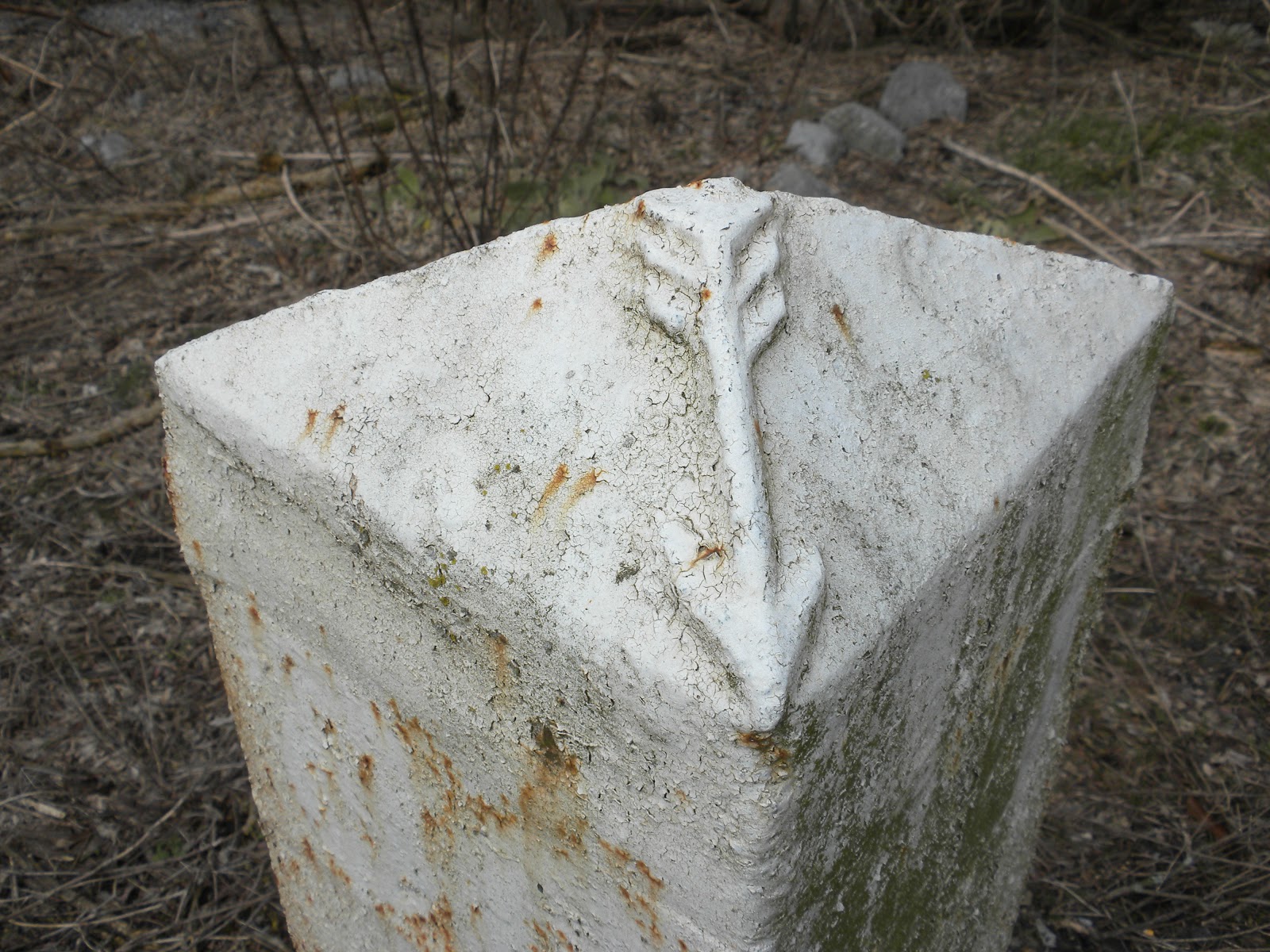
Most lines have mile markers along them.  This one is of note because the newer marker (the 60 sign on a tall post) still has the old marker (the white pyramid) immediately adjacent.

Loaction: from northbound U.S. Rt 11 about 3 miles north of Greencastle, PA, turn right onto the Clay Hill Road.  Go about 1/2 mile; pass under the railroad overpass; immediately turn right onto Friendship Village Road and pull off on the right.  Walk over towards the tracks and the grain elevators beyond.  The mile marker is easily seen, close to the RR overpass and beside the grain elevators.


Closer up for more detail.  The old "60" mark is still faintly visible on the white iron post:


But the real interesting thing to me per the photo below is the detail on the top of the old white marker: an arrow pointing towards the tracks.  The post is made of iron and is about 4' tall.  Undoubtedly the newer post is "better" (i.e., easier to see, longer lasting, cheaper, whatever) but it just doesn't have the charm of the old post.

Back in the day craftspeople did aesthetic things--art, if you will--to enhance otherwise functional objects.  Just because it was pleasing to the eye and soul...or just because.  It's pretty much a lost concept now with the total focus of business strictly on the bottom line.

 
[all photos by Gary]


Friday, February 22, 2013

Where I Run: To the Garage

Not my garage; that's attached to the north end of my house (it'd be a rather short run).  But running to and from the garage that works on my vehicles, which is situated some 10 miles away--what I'd call a perfect "destination run."

My truck was in for its annual PA state inspection, and picking it up was presenting some logistical difficulties.  So after dropping Mister Tristan (the 5-year-old human being, not the blog) off at preschool, I had about 2:15 before I again had to be back for pick-up. 

So I ran down for the truck.  I say "down" just because the direction is south.  I know it's no more down than it is up--much like it seems like the Nile River cannot possibly flow north...it's uphill, for crying out loud!--but nevertheless that's the way it feels.

Along the way I snapped a shot of the Whitetail Ski Resort (Mercersburg, PA), as viewed from near my house across the Norfolk Southern Railroad tracks:


Then the local school district's environmental center, where a large limestone spring rises, forms a pool, then eventually exits via a very cold 5' diameter water wheel:


Monday, February 18, 2013

Where I Run: The Patriarchy

Do you see anything worng with this picture?


Image by Gary (click to enlarge enough to read the names and dates, then ESC to return here), taken at a farm along Guitner Road in southern Franklin County, PA.

Gotta love the pride that comes from a farm being continually in a single family for nearly 300 years.  That is indeed exceptional and noteworthy.  The farm is tidy and prosperous-looking, sitting as it does among well-tended fields and farm buildings on the low bluffs above the Conococheague Creek.

However....something is missing.  Through some 10 generations of Kings, this sign depicts not even one woman.  Surely all those generations of men did not adopt their children; undoubtedly there were wives and mothers to fuel the reproductive engine that perpetuated the proud lineage.

Yet not a single mention of a woman.  You don't have to be a feminist to notice the omission and if upon reflection you don't feel, well, a bit uncomfortable about it, you should.

For families like the Kings consist of partners who produced and raised the children over those 10 generations.  The unknown and unmentioned mothers were there every step of the way to birth and raise not only the listed male heirs but their sisters and younger brothers.

Being a male, I believe I have been accustomed since birth to a subtle or no-so-subtle worldview that men are better, smarter, dominant, etc.  It takes an enlightenment followed by continual self-awareness and self-monitoring to ensure that equal credit goes to the women of our world.


Friday, February 1, 2013

Where I Run: The Southern PA Iron and Railroad Company

A couple of weeks ago I posted about one of my road routes from the house along the appropriately named Stone Bridge Road.

That same route also contains evidence of the former Southern Pennsylvania Iron and Railroad Company right of way, and a bridge that I've blogged about previously, here (where I have a couple additional photos at bridge level). 

This is an abandoned Pratt Through Truss bridge (circa 1896) over Conococheague Creek:


[Image credit: a way cool site called Bridgehunter]
 
 
A couple of miles further west the railroad right of way runs through what now is a pasture.  The embankment is largely gone, but the farmer wisely saved a small bridge that carried the railroad across a small stream:
 
 
[Image credit Gary]
 
 
Last view is just of the abandoned grade of the railroad, right near the Stone Bridge:
 
 
[Image credit Gary.  This section, unfortunately, is on private ground that is posted with No Trespassing signs]


Friday, January 25, 2013

Where I Run: Stone Bridge

One of my road routes from the house is along the appropriately named Stone Bridge Road--so named for the 2-arched limestone bridge that there crosses the East Branch of the Conococheague Creek:

View from the downstream side


View from the upstream side

These images show that there is a modern, two-lane concrete bridge superstructure superimposed upon the underlying original 1-lane, 2-arch limestone bridge. 

Most people know little of the underpinnings of society--what makes things work--and I suspect this bridge falls into the same category.  I doubt whether even half the people who use it every day even know that they are driving on an antique (but fully functional) structure.

This is what the circa-1850 bridge would have looked like originally.  This photo is of the nearby Social Island Road bridge, from a way cool site called Bridgehunter:


Saturday, December 15, 2012

Where I Run: Mason-Dixon Line Marker (Mile105)

I posted about a month ago on the Mile 100 Mason-Dixon Line marker that I had just visited and photographed.  Here's another one, Mile 105.


[photo by Gary]

This is a "crown stone" placed every 5 miles, meaning that bears the crests of the Calverts and the Penns in lieu of the usual "M" and "P", respectively.  The north-facing crest visible here is that of the Penn family of Pennsylvania.  For scale, the stone is about knee-high.

Immediately behind the stone (this view is facing south) the pasture in inhabited by...llamas, unknown in these parts in the 1760s:


This is a great site for on-the-ground stone location information. I've found it very useful and specific.


Thursday, November 8, 2012

Where I Run: The Mason-Dixon Line (Mile 100)...and Ultrarunning

The bride dropped me off on her way to work and I scoped out a couple of the actual line markers for the Mason-Dixon Line in southern Franklin County, PA.  The Line and its marker stones are nearly 250 years old.

This stone is at Mile 100 of the Line...right in somebody's front yard (would that be cool, or what!?).


[image credit Gary]
 

I have previously posted about The Line here and here.  Per the Maryland Historical Society,

The Mason and Dixon Line (or Mason-Dixon Line) runs for 233 miles along parallel 39°43’ in the eastern United States, marking the boundary between Maryland and Pennsylvania. The line was surveyed by English astronomers Charles Mason and Jeremiah Dixon in 1763-1768 to settle property disputes between the Penns and the Calverts, proprietors of Pennsylvania and Maryland, respectively.


This is a great site for on-the-ground stone location information. I've found it very useful and specific.

The link to Ultrarunning is that I LOVE to combine training runs with history.  Having a destination to run to or past, packing a camera, is so exciting, espeically if there is an element of searching or discovery involved.  Plus the notion that you are checking something out that never even appears on the radar screens of most "normal" people.

I can't count the times when I've been having a discussion about, say, geography, with somebody, and when I mention the Appalachian Trail, or the Skyline Drive, or the Mason-Dixon Line, all I get are blank stares.  It's kinda sad, actually.


Monday, September 10, 2012

Where I Run: Leslie Nielson


Nostalgia post today for those of you who watched TV (specifically Disney) in 1959 and 1960. 

Yesterday morning I ran my beloved Pig Farm 10 miler.  Photo above shows one of the road signs along that route that triggered me (actually it takes very little to trigger me).

The pig farm has been gone for decades now but I still call the route that, because it dates back to my formative years of running, long before I discovered the magic of trail running.

Anyway, while I was running I was passed by Leslie Nielson.  Passed because--unfairly, in my estimation, he was on horseback--and I was on foot.  After I finished the run I protested loudly to the bride.


 [image credit Steve Burns]


I gotta check more into local place names.  After all, somebody, sometime, had to name a road or a village; such a decision should not have been taken lightly.  Its' fun to try to discover the original intent.

I originally posted about this road sign a couple years ago, here.

For those of you who need more info about the photo immediately above, here you go:

In the 1950s and 1960s, the Disney television show often featured serialized stories of great Americans. People who had helped to shape the nation during its early days. Or perhaps people who had overcome some adversity. One such American was General Francis Marion.

Francis Marion, better known as the Swamp Fox, helped to turn the tide of the Revolutionary War. His unconventional fighting tactics included hiding in the Carolina swamps and attacking the British as they marched in formation. Because of this, his opponents accused him of abandoning the gentlemanly ways of fighting, which consisted of meeting your enemy face to face. Because Marion and his men knew the swamps so well, the British never could find him or anticipate his attacks.

Disney's version kept the main points of history, although perhaps presenting a somewhat sanitized view of things. The British were under the command of General Cornwallis and Colonel Tarleton. Also serving as villains were the Tories, those colonists who were still loyal to British rule. Marion was helped in his fight by his fiancee, Mary Videau, and her parents. The Videau family posed as Tories and then passed information along to Marion and his men.

Leslie Nielsen starred as General Marion, long before Nielsen's days as Frank Drebin in the Police Squad television show and the Naked Gun movies. The series also featured such Disney regulars as J. Pat O'Malley and Slim Pickens. Hal Stalmaster, from Disney's movie of Johnny Tremain appeared in the series, as did Tim Considine, who had previously appeared as Spin on in the Spin and Marty serials on the Mickey Mouse Club and later appeared as Mike Douglas in My Three Sons.

Disney obviously had high hopes of the Swamp Fox achieving the same popularity as Davy Crockett. Here was another great American hero who had practically reached folk hero status. Each episode featured action and intrigue. Marion wore a fox tail on his hat, and his men wore feathers on theirs. And he even had a catchy theme song, with words by Lew Foster and music by Buddy Baker. But for whatever reason, the Swamp Fox didn't quite catch on as the King of the Wild Frontier did. Eight episodes aired between 1959 and 1961. A single version of the theme song was released with Leslie Nielsen providing vocals, but that song didn't climb the charts like the Ballad of Davy Crocket did.

Even though the show may not have been as popular as its predecessor, it was still fun to watch and made for great television. The Swamp Fox found a whole new set of fans when the episodes were aired on the Disney Channel in the 1980s and 1990s. Now that the Disney Channel has dropped its Vault Disney programming block, the Swamp Fox is no longer seen. But perhaps this Revolutionary War hero is hiding somewhere, just waiting to make another appearance!


Tuesday, July 10, 2012

Where I Run: Barn Decor


[photo by Gary]

This found along PA 16 just east of Greencastle, PA.  I've only ever run past here once, as it is at the limit of my range from the house, but have always been smitten with this artistic spin on simple barn ventilation.

The property is threatened by development and may not survive much longer.  Hopefully the barn will be preserved as a wonderful example of form not always following function.